
Rwenzori Mountains National Park protects about 996 sq km of mountain country in western Uganda, along the border with the Democratic Republic of Congo. The park contains the Ugandan side of the Rwenzori range, rising from forested foothills to glaciers and high alpine terrain on Mount Stanley, where Margherita Peak reaches 5,109 metres above sea level. It is Uganda’s highest point and the third-highest summit in Africa. The park was established in 1991 and became a UNESCO World Heritage Site in 1994. The main reason to visit the Rwenzori is hiking. Multi-day routes climb through montane forest, bamboo, giant heather, boggy valleys and Afro-alpine moorland before reaching the high peaks. The Central Circuit from Nyakalengija and the Kilembe Trail are the two main approaches used for longer mountain treks, while other routes and lower-slope walks give travellers alternatives to a full Margherita Peak expedition. You do not need to be a technical climber or spend a week on the mountain to experience the park. Shorter hikes explore forests, rivers, waterfalls and the lower valleys, making the Rwenzori accessible to travellers with only one or two days available. For experienced trekkers, however, the journey towards Margherita Peak is one of the most demanding and rewarding mountain experiences in East Africa.
Rwenzori Mountains National Park Quick Facts
| Location | Western Uganda, along the Democratic Republic of Congo border |
|---|---|
| Park Size | About 996 sq km |
| Highest Point | Margherita Peak, 5,109 metres above sea level |
| National Park Since | 1991 |
| UNESCO World Heritage Site | Since 1994 |
| Bird Species | 217 recorded species |
| Main Experiences | Multi-day trekking, summit climbing, short hikes, birding and nature walks |
Hiking and Climbing in Rwenzori Mountains National Park
Hiking is the main experience in Rwenzori Mountains National Park, but the mountain gives you far more choice than a single climb to Margherita Peak. You can spend a day walking through the lower forest, take several days to reach the Afro-alpine zone, climb one of the lower peaks, or commit to a full expedition towards Mount Stanley and Margherita Peak at 5,109 metres. A long Rwenzori trek changes dramatically as you gain altitude. The first stages pass through montane forest and bamboo before opening into giant heather, wet valleys and some of the mountain’s famous bogs. Higher still, the landscape becomes Afro-alpine, with giant lobelias, groundsels, moss-covered valleys, rocky ridges and glacial terrain. It is this progression through completely different mountain environments that makes the Rwenzori trek so distinctive. For high-mountain trekking, the three routes to understand are the Central Circuit, Kilembe Trail and Bukurungu Trail. The right one depends on how many days you have, how much high-altitude experience you bring and whether reaching Margherita Peak is your main objective.
Central Circuit Trail
The Central Circuit starts from Nyakalengija and gives you the classic approach into the central Rwenzori. It is the route associated with many of the mountain’s best-known camps and landmarks, including Nyabitaba, John Matte, Bujuku, Elena, Kitandara and Guy Yeoman. The climb begins in the lower forest before moving into bamboo and heather, then reaches the wetter high-altitude valleys. One of the most memorable sections is Bigo Bog, where the trail crosses a broad wet valley surrounded by giant lobelias, groundsels and steep mountain slopes. Boardwalks now cover substantial parts of the boggiest terrain, although mud, water and slippery ground remain part of a Rwenzori trek. If you are climbing Margherita Peak, the route continues through Bujuku Valley towards Elena Camp, which sits high on Mount Stanley and serves as the final staging point before the summit climb. Elena now has a larger mountain facility with sleeping accommodation, water, power, a kitchen and dining space for trekkers and support teams. Allow at least seven days on the mountain for a Mount Stanley ascent using the Central Circuit. The route suits strong hikers who want the traditional Rwenzori experience and are comfortable with steep climbs, boggy valleys, cold nights and long days at altitude.
Kilembe Trail
The Kilembe Trail starts from the Kilembe side of the mountain, south of Kasese, and climbs into the Rwenzori through a different sequence of valleys from the Central Circuit. It is one of the strongest choices for travellers who want a longer, more gradual progression towards the high peaks. The lower stages pass through forest before climbing into bamboo, giant heather and open Afro-alpine country. Higher up, the route enters broad valleys surrounded by steep ridges and peaks, with the vegetation becoming increasingly dramatic as you approach the central mountains. For a full Mount Stanley expedition, allow about nine days on the Kilembe route. If you want the high-altitude Rwenzori experience without attempting Margherita Peak, a shorter six-day trek to Mount Luigi di Savoia, 4,627 metres, takes you deep into the Afro-alpine zone and still gives you excellent views towards the higher Mount Stanley massif when the weather opens. Kilembe works particularly well if you want more time on the mountain and prefer a route where the journey through the different vegetation zones is as important as reaching the summit.
Bukurungu Trail
The Bukurungu Trail climbs from Kitumba towards Mount Gessi and gives you a quieter approach into the Rwenzori than the Central Circuit and Kilembe routes. The trail moves from lower forest through bamboo and heather before reaching the higher mountain country. This is a good route for experienced hikers who want to spend time in a less-travelled part of the range rather than following the standard Margherita Peak programme. The changing vegetation is a major part of the walk, with dense forest gradually giving way to open heath and high-altitude landscapes as you climb. Bukurungu also shows why the Rwenzori should not be treated as a one-summit mountain. Mount Gessi, Mount Speke, Mount Baker, Mount Emin, Mount Luigi di Savoia and Mount Stanley all form part of the wider high Rwenzori, giving serious hikers several objectives beyond Margherita Peak.
Margherita Peak and Mount Stanley
Margherita Peak rises to 5,109 metres on Mount Stanley, making it Uganda’s highest point and the third-highest summit in Africa. It is the main objective for many Rwenzori trekkers, but reaching it requires several days of gradual climbing through the lower forest, bogs, Afro-alpine valleys and high mountain camps. The final approach is much more technical than the lower trekking routes. Above 4,000 metres, conditions become colder and more exposed, while the summit section involves rock, ice and glacier travel using ropes, crampons and specialist equipment. Mount Stanley also has several other high peaks, including Alexandra, Albert and Elena, so the upper mountain is a broad massif rather than a single summit point. For travellers who do not want the technical climb to Margherita, the surrounding valleys, lakes and high-altitude landscapes still provide a strong Rwenzori experience.
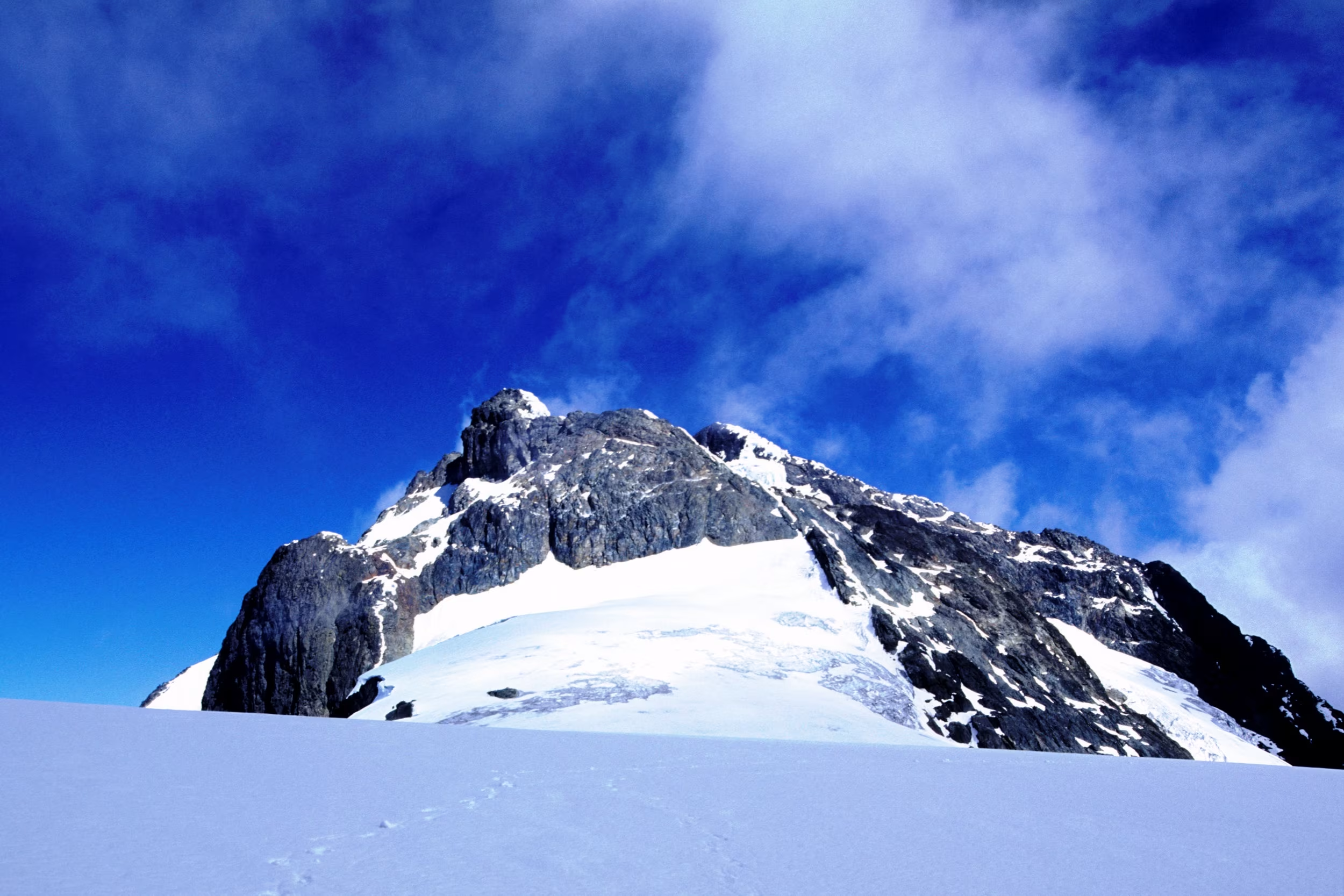
Margherita Peak
Short Hikes and Nature Walks in the Rwenzori
You do not need a week on the mountain to experience the Rwenzori. Shorter hikes from the Nyakalengija and Kilembe trailheads take you through the lower forest, bamboo and river valleys, making them suitable for travellers who want the mountain scenery without committing to a summit expedition. From Nyakalengija, one of the strongest shorter options is the two-day hike to Lake Mahoma, a scenic mountain lake reached through the bamboo forest. The lower forest around both Nyakalengija and Kilembe can also be explored on day walks, with good chances to see birds, monkeys and some of the distinctive vegetation that becomes more dramatic as you gain altitude. Another option is the Kazingo Trail, which gives you a full-day traverse across the northern Rwenzori ridge between the Fort Portal plateau and the Semliki Valley side of the mountains. These shorter hikes work particularly well if you want to experience the Rwenzori without taking on Margherita Peak.
Rwenzori Vegetation Zones and Alpine Landscapes
One of the strongest parts of a Rwenzori trek is watching the landscape change as you climb. The lower slopes begin with montane forest and bamboo, then give way to giant heather, wetter valleys and open Afro-alpine country higher on the mountain. Above roughly 3,000 metres, the vegetation becomes much more distinctive. Giant lobelias, giant groundsels, mosses and heathers dominate parts of the trail, especially around the bogs and high valleys. Higher still, vegetation thins out as the terrain becomes colder, rockier and increasingly exposed towards the major peaks and glaciers. This changing scenery is one of the main reasons not to rush the Rwenzori. Even travellers who do not reach Margherita Peak can still experience some of the mountain’s most unusual landscapes simply by spending enough time in the upper valleys.
Birdwatching and Wildlife in the Rwenzori
Rwenzori Mountains National Park has 217 recorded bird species, with many of the best sightings coming from the lower forest and montane zones. Species to look for include the Rwenzori turaco, Archer’s robin-chat, Shelley’s crimson-wing, dwarf honeyguide, Grauer’s cuckooshrike, Lagden’s bush-shrike and several sunbirds. Wildlife is present, but sightings are less predictable than in Uganda’s savannah parks. The lower forests support L’Hoest’s monkeys, blue monkeys, chimpanzees, forest elephants and the localized Rwenzori duiker. Higher up, hyraxes are among the animals more commonly associated with the rocky mountain zone. For most visitors, birding and wildlife fit naturally into the hike rather than becoming separate activities. The slower you move through the lower forest, the better your chances of noticing both.
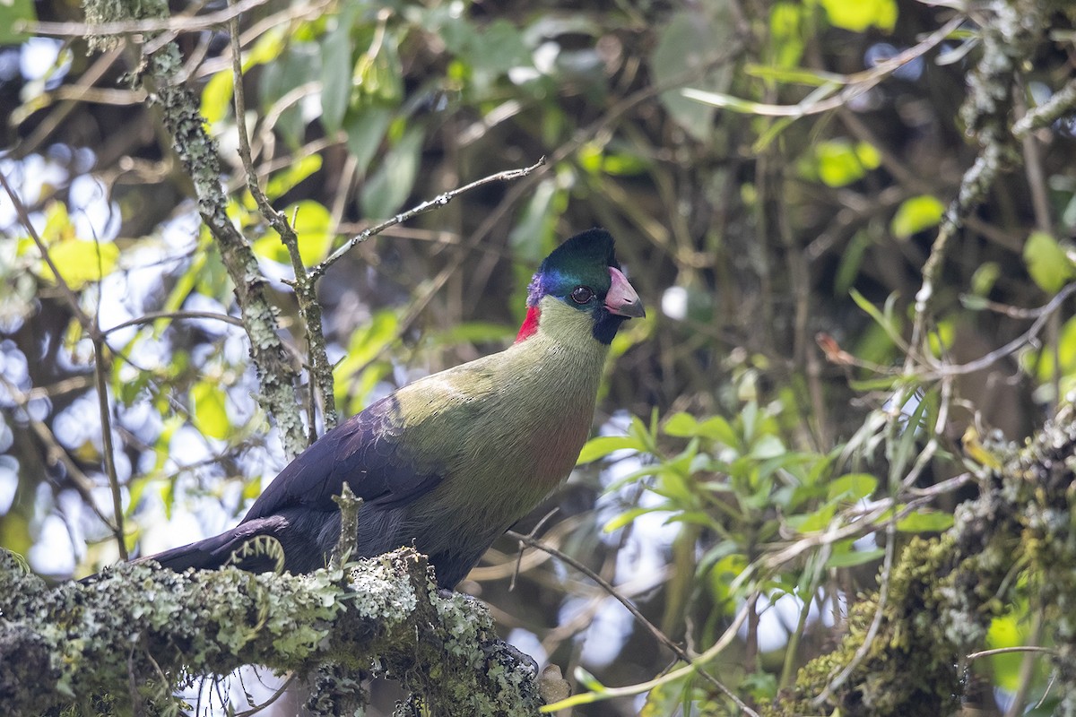
Rwenzori turaco
Bakonzo Communities and the Rwenzori Foothills
The lower slopes of the Rwenzori are home to the Bakonzo people, whose history and traditions are closely tied to the mountain. For generations, the peaks, valleys and forested slopes have carried cultural and spiritual meaning, with sacred sites forming part of the wider Rwenzori landscape. For travellers, the most practical community experiences are found around the foothills near the main trailheads. These can include guided village walks, homestead visits, traditional performances and locally prepared food, giving you a better understanding of life around the mountain before or after a trek. These visits work best as a complement to the hiking experience. They add context to the Rwenzori by showing how closely the mountain is connected to the people living around its lower slopes, rather than treating it only as a climbing destination.
Rwenzori Mountains National Park Fees
Rwenzori Mountains National Park has separate charges for park entry and mountain activities. For a multi-day Rwenzori trek, these charges are only part of the overall cost. Mountain guides, porters, accommodation or camps, meals, climbing equipment and trekking logistics are arranged separately depending on the route and number of days. This becomes particularly important for Margherita Peak expeditions, where specialist equipment and a larger mountain support team are required.
| Activity | Foreign Non-Resident | Foreign Resident | East African Citizen |
|---|---|---|---|
| Park Entry | US$35 | US$25 | UGX 15,000 |
| Rwenzori Mountain Hike | US$50 | US$40 | UGX 50,000 |
| Bukurungu Trail | US$50 | US$40 | UGX 50,000 |
| Kazingo Trail | US$50 | US$40 | UGX 50,000 |
How to Get to Rwenzori Mountains National Park
Rwenzori Mountains National Park is reached through Kasese in western Uganda, with the final approach depending on the trail you are hiking. Kasese is about 375 km from Kampala through Fort Portal or roughly 450 km through Mbarara. The main trekking routes then branch towards Nyakalengija, Kilembe or Katebwa.
Getting to Nyakalengija and the Central Circuit
For the Central Circuit, travel north from Kasese towards the Mubuku Valley and continue to the trailhead at Mihunga near Nyakalengija. The trailhead lies about 25 km north of Kasese and around 22 km from the main Fort Portal to Kasese road. This is the starting point for the classic route through Nyabitaba, John Matte and Bujuku towards Mount Stanley.
Getting to Kilembe
The Kilembe Trail starts at the head of the Nyamwamba Valley, about 15 km west of Kasese. This makes Kasese the most convenient overnight base before starting a Kilembe trek. For the quieter Bukurungu Trail, leave the main Kasese to Fort Portal road at Nyakibya and continue about 6 km to Katebwa. You can also fly from Entebbe or Kajjansi to Kasese, then continue by road to your chosen trailhead.
Where to Stay Around the Rwenzori Mountains
Accommodation around the Rwenzori depends heavily on your trekking route. Nyakalengija and Ruboni work best for the Central Circuit, Kilembe for the Kilembe Trail, while Kasese gives you the widest choice before or after the mountain. Once the trek starts, nights are spent in designated mountain huts and camps rather than conventional lodges.
| Area or Route | Lodge/Camp or Hut | Best For |
|---|---|---|
| Nyakalengija | Ruboni Community Camp, Equator Snow Lodge | Central Circuit departures, lower-mountain walks and staying close to the Nyakalengija trailhead |
| Kilembe | Rwenzori Trekkers Hostel | Kilembe Trail departures and an overnight stay immediately before or after the trek |
| Kasese | Hotel Margherita Rwenzori International Hotel |
Travellers wanting a town hotel, easier transport connections and a comfortable pre-trek or post-trek night |
| Central Circuit | Nyabitaba Hut John Matte Hut Bujuku Hut |
Multi-day Central Circuit and Margherita Peak expeditions |
| Kilembe Trail | Sine Camp Kalalama Camp Mutinda Camp |
Multi-day trekking through the southern Rwenzori and Margherita Peak climbs |
What to Pack for a Rwenzori Trek
Packing for the Rwenzori is very different from packing for an ordinary safari. You move from warm lower forest into cold, wet and exposed high-altitude terrain, so layering, waterproof protection and reliable footwear are essential. For most treks, carry:
- Waterproof hiking boots with strong ankle support
- Waterproof jacket and trousers
- Warm fleece or insulated jacket
- Thermal base layers
- Gloves, warm hat and sun hat
- Quick-drying hiking trousers and shirts
- Daypack with rain cover
- Headlamp with spare batteries
- Refillable water bottle or hydration system
- Sunglasses and sunscreen
- Sleeping bag suited to cold mountain conditions
- Personal first-aid items and blister treatment
For Margherita Peak, additional technical equipment such as crampons, harnesses, helmets and ropes is required for the glacier and summit sections. These items should be arranged as part of the climbing setup rather than treated as normal hiking gear. Keep your daypack light and use porter support for heavier equipment on longer expeditions.
Best Time to Visit Rwenzori Mountains National Park
The best time to trek the Rwenzori is during the drier months of January, June and July, when trails are generally easier underfoot, and conditions on the upper mountain are more manageable. Even then, rain is always possible, so waterproof clothing should stay in your daypack. The wetter periods run mainly from March to May and from August to December. During these months, the lower forest becomes muddier, bogs hold more water and visibility on the higher slopes can drop quickly in mist and rain. For a Margherita Peak expedition, I would favour January or the June to July window because you are spending several days at altitude and the final summit section is already demanding without adding heavier rain. For lower forest walks and shorter hikes, the park can still be visited outside these months if you are properly equipped for wet conditions.